University Of Chicago Library. (2009). the Burnham plan centennial. Retrieved from http://burnhamplan100.lib.uchicago.edu
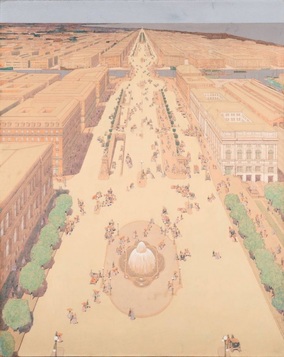
Figure 1. Chicago Plan for Michigan Avenue 1909
INTRODUCTION
For starters, urban design refers to the process of designing a city in its entirety. Buildings, open spaces, districts, public areas are all a part of the urban design process in order to make a city livable and sustainable as well as efficient and appealing to potential people that live in the city. This includes the “interrelationship” of buildings, open space, transportation, and neighborhoods to have a feel of good quality of life for the public. [1] The urban design process includes creating the master or general plan for the city which will incorporate all elements of the city to establish a functional space. With this comes the urban design and plan for Chicago. Daniel Burnham, an architect and urban designer, was the main designer for the new plan of Chicago in 1906, which was then published in 1909. With partner Edward H. Bennett, they came up with the “Plan of Chicago” as the general plan for the city of Chicago which was originally founded in 1832. [2] The Plan of Chicago hoped for activities of the city to be distributed in an efficient manner and the physical plan to be accessible in a way where we can carry on with our lives without sacrificing any convenience. The urban design of Chicago has come a long way since founded in 1832; the Chicago Plan, development of skyscrapers, the City Beautiful movement in order to beautify the city and efforts to make the vision of the city more knit together between the pedestrians and drivers, housing and commercial buildings, and historical preservations. Not only does the urban design process refer to how the city is designed, it also will include architectural style to a multiplicity of buildings, landscapes, and public spaces. Buildings in Chicago are designed to fit the look of its influences, which include Parisian and neoclassical elements.
Figure 1 source: University Of Chicago Library. (2009). the Burnham plan centennial. Retrieved from http://burnhamplan100.lib.uchicago.edu
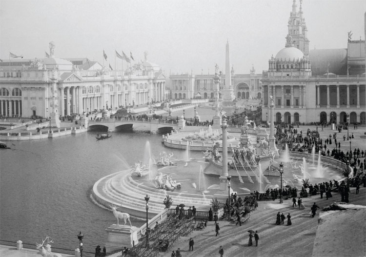
Figure 2. The "White City" as a part of the City Beautiful Movement in order to beautify the crowded city. University Of Chicago Library. (2009). the Burnham plan centennial. Retrieved from http://burnhamplan100.lib.uchicago.edu
CITY BEAUTIFUL
In response to dirty, overcrowded and highly urbanized cities, there was a pressure to de- clutter and clean the city to result in a beautifully designed and livable space. The City Beautiful Movement in Chicago became a direct response to urbanization and industrialization to make the polluted and congested city beautiful once more. [9] The World’s Columbian Exposition of 1893 was the first large scale exposition of the City Beautiful Movement in Chicago where it displayed the model city for City Beautiful with grandeur. It was directed by Daniel Burnham, where it became known as the “White City” because buildings were mostly white and they were all aesthetically monumental. This directly led to the City Beautiful Movement after 1893, and lasted until the official plan for Chicago. [9] The City Beautiful Movement was launched before the official plan of Chicago, but its principles helped to finalize the “Burnham Plan.” This architectural movement shaped the urban design of the city because it laid out what the city would strive to embody. At the 1893 World’s Fair, which was held in Chicago, Daniel Burnham launched this movement that was mainly focused around the Beaux-Arts principles. This included neoclassical temples and beautification in order to rid of the “social ills” of society. This reform movement inspired civic loyalty and a movement away from the impoverished lifestyle of many urban cities in the late 1800s. Another element of the City Beautiful Movement was a step towards resembling European cities with Beaux-Arts style architecture, which promoted neoclassical elements as well as influence from the Baroque tradition. [12] Improving the city focused on creating a civic center as the city focal point that was inviting and embracing of the city and its surrounding regions as a whole. Focus on the civic center in a Beaux-Arts style represents power, dignity, and aesthetic appeal. Painted in white, the buildings in Chicago resembled monumental yet classical buildings that were beautiful to the eye. [12] The urban design that was influenced by the City Beautiful Movement allowed for more a sophisticated, striking, and monumental feel for the design of Chicago so that there was a center of power; surrounded by smaller nodes of urban and suburban city life. Although the City Beautiful Movement was a significant aspect of Burnham’s plan for the city, it did have flaws in not addressing poverty, pressures of immigration, poor housing and overcrowding; the movement was dwindling down by 1915, leaving its “formative years to be 1897-1902. [9]
In response to dirty, overcrowded and highly urbanized cities, there was a pressure to de- clutter and clean the city to result in a beautifully designed and livable space. The City Beautiful Movement in Chicago became a direct response to urbanization and industrialization to make the polluted and congested city beautiful once more. [9] The World’s Columbian Exposition of 1893 was the first large scale exposition of the City Beautiful Movement in Chicago where it displayed the model city for City Beautiful with grandeur. It was directed by Daniel Burnham, where it became known as the “White City” because buildings were mostly white and they were all aesthetically monumental. This directly led to the City Beautiful Movement after 1893, and lasted until the official plan for Chicago. [9] The City Beautiful Movement was launched before the official plan of Chicago, but its principles helped to finalize the “Burnham Plan.” This architectural movement shaped the urban design of the city because it laid out what the city would strive to embody. At the 1893 World’s Fair, which was held in Chicago, Daniel Burnham launched this movement that was mainly focused around the Beaux-Arts principles. This included neoclassical temples and beautification in order to rid of the “social ills” of society. This reform movement inspired civic loyalty and a movement away from the impoverished lifestyle of many urban cities in the late 1800s. Another element of the City Beautiful Movement was a step towards resembling European cities with Beaux-Arts style architecture, which promoted neoclassical elements as well as influence from the Baroque tradition. [12] Improving the city focused on creating a civic center as the city focal point that was inviting and embracing of the city and its surrounding regions as a whole. Focus on the civic center in a Beaux-Arts style represents power, dignity, and aesthetic appeal. Painted in white, the buildings in Chicago resembled monumental yet classical buildings that were beautiful to the eye. [12] The urban design that was influenced by the City Beautiful Movement allowed for more a sophisticated, striking, and monumental feel for the design of Chicago so that there was a center of power; surrounded by smaller nodes of urban and suburban city life. Although the City Beautiful Movement was a significant aspect of Burnham’s plan for the city, it did have flaws in not addressing poverty, pressures of immigration, poor housing and overcrowding; the movement was dwindling down by 1915, leaving its “formative years to be 1897-1902. [9]
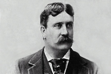
Figure 3. Daniel Burnham, lead architect of the Plan of Chicago.
PLAN OF CHICAGO
Following the City Beautiful Movement was the birth of the Burnham Plan or the “The Plan of Chicago” which was not formally established until 1909, but its project began in 1906 with the copartners who established the plan, The Commercial Club of Chicago. [9] Together they worked with the fast growing city due to booming transportation and railroads. The Plan of Chicago was majorly influenced by the design of Paris, which incorporated a central focal point and boulevards and streets emerging from the city center. The urban design that was set forth in the Chicago Plan was based off a nodal concept with a city center, streets, boulevards, fountains, and construction to resemble the design of Paris. This allowed for pedestrian-friendly cities with plenty of walkways and ways to get to the “downtown” of the city with ease. [2] The Plan of Chicago was meant to embody six elements to maintain a flourishing city. A) have physical incorporation to the land with closeness to the lake front and improving the waterfront entities, b) developing a regional highway system that is efficient in its nature, c) refining railways and terminals, d) inclusion of an open park system throughout the city, e) having systematic streets with strategic paths to the inner city, and f) the creation of a civic central “center” that includes the focus of the city with government and “cultural institutions.” [6] The plan, more commonly known as the “Burnham Plan” was embraced by middle class and businessmen because it strived to tie in the market with infrastructure, roads, and highways to aid with the growth in the automobile age and also the influx of people living in the area with a prime focus on the business district. The plan would present an orderly street system and ease of access to the business district in the center of the city. Michigan Avenue would extend into the business district provided with shops and office buildings, known as the “Miracle Mile.” [7] With the nodal center city, and surrounding areas of residential, there is a functional way to mix business with residential neighborhoods and suburbs in an efficient manner to make the city have a desirable and livable design benefitting primarily the business elite but also all citizens in surrounding areas.
Figure 3 source: The columbian exposition . (2013). Retrieved from http://ecuip.lib.uchicago.edu
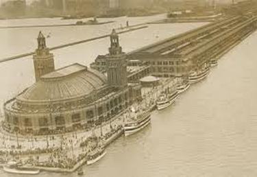
Figure 4. Navy Pier in the early 1920's, after it opened in 1916
6 ELEMENTS OF BURNHAM PLAN
A) Improving lakefront: The plan wanted to reclaim the lakefront that sorrounds Chicago in order to allow the public to be more in touch with it because it “belongs to them.” This design element allowed for trade, commerce, and appeal to the growing city during the early twentieth century. The plan suggested building parks along waterfront and expanding harbor facilities in proximity to the water. [11] An example of incorporation of this urban design is shown in the Navy Pier built on the shoreline of Lake Michigan. It was opened in 1916 as part of the plan to serve as appealing public infrastructure where gatherings and entertainment can take place for the general public. It combines shipping business with “recreational and entertainment activities that encompass parks, gardens, shops, restaurants” which stimulated growth and success. Even today, it is a very popular tourist attraction for visitors to Chicago. [9] Also, to improve trade the Chicago River was “straightened and enhanced” to reverse the flow of the river so that trade would be more effective and successful. [11]
B) Regional Highway: A highway system would allow for ease of connection to the center city of Chicago to surrounding nodes, which is especially crucial during the emergence of the automobile age. This urban design element of a central business city center and surrounding residential is in order to create a de-clustering of the urban downtown. Highways were built to be radial and circumferential in order to allow for automobiles to have eased when commuting in the 1920s. [11]
C) Improving railways: This would allow for better transportation to and from the city, which can allow for more trade and more commercial appeal to the city. In the plan, this would lead to economic growth for booming Chicago. Expansion of the railways would lead to enlargement of the business district south and outward. [11] For more information, see transportation.
D) Open parks: Preservation of natural areas would allow for a connection to open space. This is important to the design of the city because it gives open spaces and pathways for pedestrians to roam freely. Not only was this element important to the Burnham plan, other landscape architects such as Frederick Law Olmstead, Frank Gehry and Lorado Taft recognizing the importance of open parks and facilities to a city. [10] Famous parks include Portage Park, Jefferson Park and Pulaski Park, Millennium Park, Grant Park and Lincoln Park. Grant Park served as an embodiment of the grandeur yet importance of open space for the urban design of Chicago so that it adheres to its citizens. [8] Overall, parks were crucial to citizens who could not afford travel and it provided a convenient area for any class for the public. [11] Parks were a place that could not be sacrificed for the sake of the city. Even today, there are efforts to preserve parks to keep that element of open space for the public health and benefit. In the 1940’s the Chicago Park District established a ten year plan to improve and expand upon parks, and in 1959 it was again expanded. Today it results in over eight thousand areas of open space, including parks, benches, nature areas, etc. [10]
E) Systematic streets: Incorporation of wider street ways that were set out in diagonal pathways would help to connect the civic centers to the surrounding areas but also were designed to relieve traffic. During the official planning of Chicago, in the early 1920s, there was the rise of the automobile so these wider street ways aided in the growth of car ownership. This makes a city livable and appealing to both automobile owners, but also pedestrians because the design incorporated both walking and travel areas. Some streets were even widened due to automobile growth in 1915 -1931. [11] Several diagonal planned streets are Ogden Avenue, Roosevelt Road, and Michigan Avenue. The main city’s axis for the streets was centered on Congress Street, which would create a main avenue for the new organized street pattern. [11]
F) Civic Center of City: In an effectively planned city, there is the main focus on the center based around government and business/ commercial districts. Sometimes known as a “downtown” or even a monumental civic center. Burnham proposed a cultural center in Grant Park as the central axis of the city, which would be the field Museum. [11]
Figure 4 source: University Of Chicago Library. (2009). the Burnham plan centennial. Retrieved from http://burnhamplan100.lib.uchicago.edu
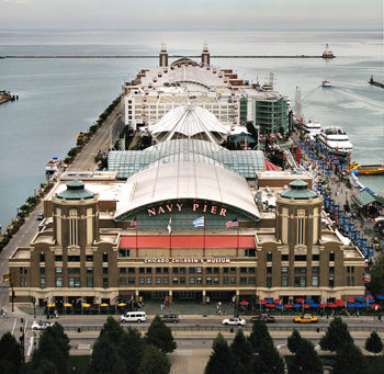
Figure 5. Navy Pier aerial view in 2011. Chicago architecture today. (2006). Retrieved from http://chicagoarchitecturetoday.com/index.htm
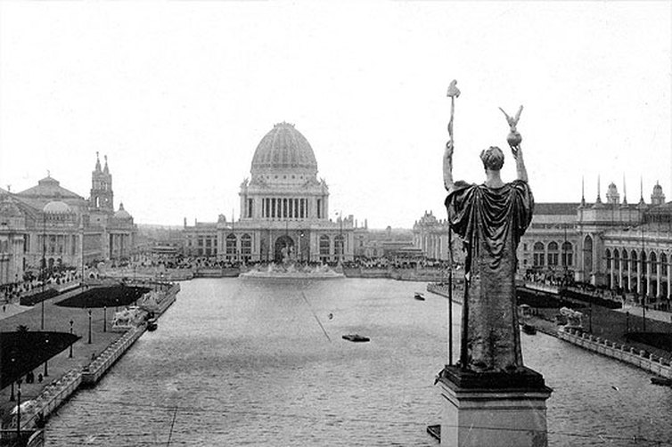
Figure 6. Administration Building in front of Grand Basin in 1920s. The columbian exposition . (2013). Retrieved from http://ecuip.lib.uchicago.edu
INFLUENCE AND DESIGN STYLE
When looking at buildings and architecture of Chicago’s landscape, you will see work that modeled elements of the classical style of Greece and Rome. These elements include incorporation of the outdoor space as very important to the life of the city. Enclosed indoor spaces were not necessarily what classical Greek architecture gave to Chicago’s urban design however. Rather, the open outdoor spaces paved way to influence Burnham and his colleagues to have many parks, proximity to the waterfront, and open areas to adhere to the outdoor city life, as shown through European styles such as Baroque and Parisian influence. [5] Arches, vaults, columns and cathedral resemblances also influenced the building style of Chicago as shown through grandeur of monumental planning with early buildings. There were also neoclassical and baroque elements found in the buildings of Chicago throughout the late 1800’s and early 1900s. An example of a “grand” and monumental building is the Administration Building on the Grand Basin, which was featured at the Columbian Exposition of 1893, showcasing City Beautiful. This building incorporated grand arches, columns and a dome with proximity to Lake Michigan and multiple entrances with wide boulevards. [9] With the central focal point being a large building that incorporates government urban planners can bring back neo-classical ideals with the design of Chicago. Burnham was also influenced by Paris. For example, from Haussmann’s renovation of Paris in the late 1860s, he wanted to recreate the focus on a civic center in the shape of a “half-crescent boulevard” to enclose a portion of the city. [5] This reveals how the design of Chicago contained heavy European influence in the early 1900s when the building of the city was taking place.
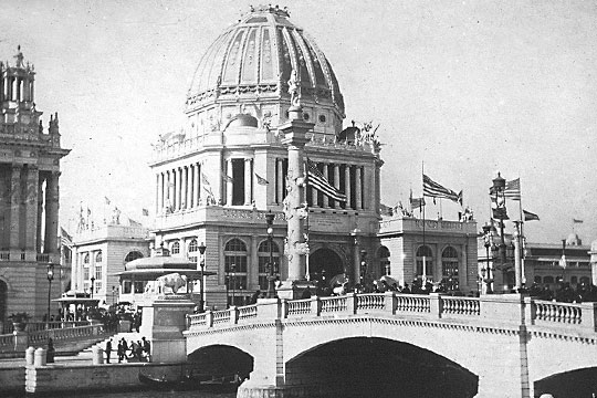
Figure 7. Arches and columns at the Administration Building show the influences of neoclassical architecture. The columbian exposition . (2013). Retrieved from http://ecuip.lib.uchicago.edu
POST 1909 PLAN
Not too long after establishing the Chicago Plan, Burnham passed away but his legacy for the urban design of Chicago lived on. In 1913, Edward Bennett was hired as an architect to begin to implement the work of Burnham. With minor alterations and more of a focus on the parks movement, the plan seemed to be successful with the basic attributes. Revised plans focused more on a French Renaissance style with formal symmetry in outdoor areas. [8] One major revision that Bennett implemented was a fountain in the place of where Burnham envisioned the Field Museum as the “center” of the main park. Again inspired by the French Style, the Buckingham Fountain was completed in 1927 in the center of an open park. [8] Today, the iconic fountain remains, giving the same urban design feel that these architects and planners had in the early twentieth century of wide open spaces. Throughout the 1920s and continuing on into the 30s, 60s and 70s, elements of the original urban design of Chicago lived on to encompass the need for parks and preservation of space. Some examples of this are the 1929 Shedd Aquarium which “harmonized” the Field Museum and open areas that are focal points. In 1973, the Lakefront Protection Ordinance was put into action which protected the lakefront to keep it free of built infrastructure and aspects that would ruin the feel of nature. [8] These elements of preserving the lakefront and waterways, and access to open space live on today in Chicago; the Chicago Park District is merely one organization that is active today that works to better public serving through parks so that there is connection to nature. [8] For further information, reference the Chicago Park District Official Website. http://www.chicagoparkdistrict.com/about-us/. This site gives information of what they as an organization strives for and how they want to implement preservation of open space in the future. For the most part, architects and planners that followed the basic elements of the Burnham Plan allowed Chicago to have the same “vibe” of the city that he wanted. This holds to be true as shown through the Walk Score survey, which measures and rates cites according to their walkability and rate of people walking to and from places in cities. According to Walk Score, Chicago is fourth in the nation is relation to walkability. Some Chicago neighborhoods that highlight walking are Printers Row and Near North. [14] Chicago today has features of design that were important throughout the city plan, as shown through this pedestrian friendly neighborhood streets.
Not too long after establishing the Chicago Plan, Burnham passed away but his legacy for the urban design of Chicago lived on. In 1913, Edward Bennett was hired as an architect to begin to implement the work of Burnham. With minor alterations and more of a focus on the parks movement, the plan seemed to be successful with the basic attributes. Revised plans focused more on a French Renaissance style with formal symmetry in outdoor areas. [8] One major revision that Bennett implemented was a fountain in the place of where Burnham envisioned the Field Museum as the “center” of the main park. Again inspired by the French Style, the Buckingham Fountain was completed in 1927 in the center of an open park. [8] Today, the iconic fountain remains, giving the same urban design feel that these architects and planners had in the early twentieth century of wide open spaces. Throughout the 1920s and continuing on into the 30s, 60s and 70s, elements of the original urban design of Chicago lived on to encompass the need for parks and preservation of space. Some examples of this are the 1929 Shedd Aquarium which “harmonized” the Field Museum and open areas that are focal points. In 1973, the Lakefront Protection Ordinance was put into action which protected the lakefront to keep it free of built infrastructure and aspects that would ruin the feel of nature. [8] These elements of preserving the lakefront and waterways, and access to open space live on today in Chicago; the Chicago Park District is merely one organization that is active today that works to better public serving through parks so that there is connection to nature. [8] For further information, reference the Chicago Park District Official Website. http://www.chicagoparkdistrict.com/about-us/. This site gives information of what they as an organization strives for and how they want to implement preservation of open space in the future. For the most part, architects and planners that followed the basic elements of the Burnham Plan allowed Chicago to have the same “vibe” of the city that he wanted. This holds to be true as shown through the Walk Score survey, which measures and rates cites according to their walkability and rate of people walking to and from places in cities. According to Walk Score, Chicago is fourth in the nation is relation to walkability. Some Chicago neighborhoods that highlight walking are Printers Row and Near North. [14] Chicago today has features of design that were important throughout the city plan, as shown through this pedestrian friendly neighborhood streets.
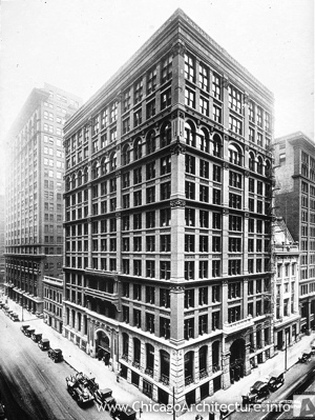
Figure 8. Home Insurance Building built in 1905
BUILDINGS/INFRASTRUCTURE
The design of the city incorporates both large skyscrapers and nodal areas for residential homes. The buildings of skyscrapers allow for bigger business in the city creating an urban vibe while still keeping the suburban qualities of a livable city. Built in the duration of 1834-1939, skyscrapers emerged in the late nineteenth century. [13] Early skyscrapers in Chicago were lower than the typical skyscrapers seen in New York. Low rise buildings were the commercial center of the Chicago with emphasis on business. A prominent skyscraper known for the model of Chicago skyscrapers is the Home Insurance Building, ten stories high and built in 1905 by William Le Baron Jenney, was officially Chicago’s first skyscraper. [13] They took styles of metal framework and incorporated many windows throughout, even though they were low rise. [13] As years progressed, towers resembled temples and become more neo-classical as the City Beautiful Movement approached. Buildings for the most part continue to stand today even though as time progresses there is a shift toward more sustainable infrastructure. As buildings change and become more advanced, sustainable, and even taller, the design of where this are located and in what fashion remains closely related to the early twentieth century.
Figure 8 source: Chicago architecture info. (2013). Retrieved from http://www.chicagoarchitecture.info/Building/3168/The-Home-Insurance-Building.php
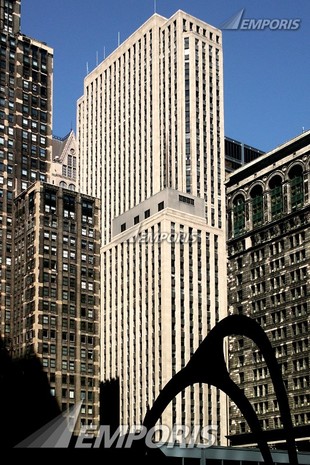
Figure 9. LaSalle Bank Building, which replaced the Home Insurance Building in 1934. Emporis. (2000). Retrieved from http://www.emporis.com/building/lasalle-bank- building-chicago-il-usa
CURRENT URBAN DESIGN RENOVATIONS
As population is steadily increasing in Chicago, there is a need to plan for the growing numbers. Today the population is roughly 8,600,000 and there is an estimate that by 2040, the population will increase by 25%. [15] Although Chicago’s urban design and plans have been, for the most part, successful over the past one hundred years, this increased growth has triggered the need for more sustainability and accommodation for such massive growth in such a populated booming economic area. Recently, the Chicago Metropolitan Agency for Planning has constructed the GO TO 2040 plan which will adhere to transportation, residential and commercial problems. [15] The reasons however for this new plan stem from the concepts of the original design plans for the city; need for open space and preservation of water to name a few. With the increased population, there are implications that destroy natural resources including open space, water and air quality. Hence, the new plan will return these elements back to the importance that they should be given to have that livable quality to the city. The Chicago Metropolitan Agency for Planning notes that “by implementing GO TO 2040, residents will have more options for getting around, more options for housing, more jobs nearer to where they live, more parks and open space, more plentiful and cleaner water, healthier air, and better quality of life.” [15] Along with the better quality of life, we now enjoy parks, lakefront and forest preservation as implemented by Daniel Burnham, however the new plan only hopes to revise these areas and connecting areas in order to keep them “green.” [15] Focus on sustainability is a major part of the GO TO 2040 plan, something that we did not necessarily need to think about in 1909. More on sustainability can be found in the sustainable development tab. Detailed features of the plan can be found at http://www.cmap.illinois.gov/c/document_library/get_file?uuid=018be2f0-70cc-4f54-a1df-06cdd125dd6f&groupId=20583, the short version of the GO TO 2040 plan. Although this plan is not yet enforced, there are high hopes for the future for greater sustainability, more jobs and better life that is designed for the people.
As population is steadily increasing in Chicago, there is a need to plan for the growing numbers. Today the population is roughly 8,600,000 and there is an estimate that by 2040, the population will increase by 25%. [15] Although Chicago’s urban design and plans have been, for the most part, successful over the past one hundred years, this increased growth has triggered the need for more sustainability and accommodation for such massive growth in such a populated booming economic area. Recently, the Chicago Metropolitan Agency for Planning has constructed the GO TO 2040 plan which will adhere to transportation, residential and commercial problems. [15] The reasons however for this new plan stem from the concepts of the original design plans for the city; need for open space and preservation of water to name a few. With the increased population, there are implications that destroy natural resources including open space, water and air quality. Hence, the new plan will return these elements back to the importance that they should be given to have that livable quality to the city. The Chicago Metropolitan Agency for Planning notes that “by implementing GO TO 2040, residents will have more options for getting around, more options for housing, more jobs nearer to where they live, more parks and open space, more plentiful and cleaner water, healthier air, and better quality of life.” [15] Along with the better quality of life, we now enjoy parks, lakefront and forest preservation as implemented by Daniel Burnham, however the new plan only hopes to revise these areas and connecting areas in order to keep them “green.” [15] Focus on sustainability is a major part of the GO TO 2040 plan, something that we did not necessarily need to think about in 1909. More on sustainability can be found in the sustainable development tab. Detailed features of the plan can be found at http://www.cmap.illinois.gov/c/document_library/get_file?uuid=018be2f0-70cc-4f54-a1df-06cdd125dd6f&groupId=20583, the short version of the GO TO 2040 plan. Although this plan is not yet enforced, there are high hopes for the future for greater sustainability, more jobs and better life that is designed for the people.
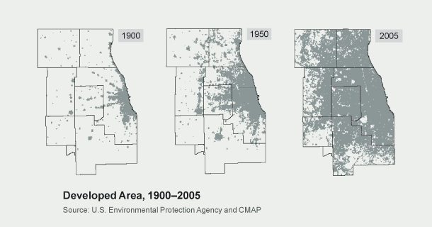
Figure 10. Increased population growth over decades, leads to a need for accommodation of the urban design to fit the citizens needs. Chicago metropolitan agency for planning. (n.d.). Retrieved from http://www.cmap.illinois.gov/2040/a-pivotal-moment
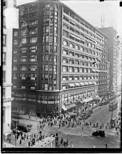
Figure 11. Intersection of State and Madison in 1926.
EXAMPLES OF NEW BUILDINGS IN RELATION TO OLD
Although there are many new buildings and centers in Chicago, some still are standing; with renovation in mind. One is Navy Pier; the once booming tourist attraction has died down over the years, but still possesses the same elements it was once intended for. Aesthetically, they still resemble each other quite a bit. [16] One famous building that does not still exist today is the ever popular Home Insurance Building. Torn down in 1931, it was merely moved to make way for a newer skyscraper, now the Field Building more commonly known as the LaSalle Bank Building. [17] Although a few buildings were torn down over time, the original skyscraper paved way for steel framed buildings, safe elevators and modern plumbing. [17] These design elements allow for the emphasis on commercial, economic, and business districts but still allowed for urban design elements of the past.
Figure 11 source: University Of Chicago Library. (2009). the Burnham plan centennial. Retrieved from http://burnhamplan100.lib.uchicago.edu
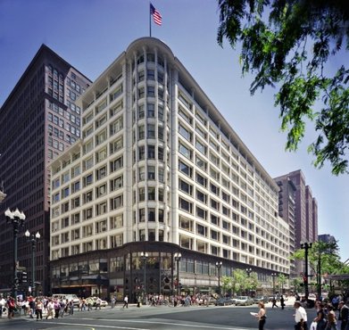
Figure 12. The same building, at State and Madison in 2007. Both images found at: University Of Chicago Library. (2009). the Burnham plan centennial. Retrieved from http://burnhamplan100.lib.uchicago.edu
___________________________________
FOOTNOTES
[1] Schurch, T. W. (1999). Reconsidering urban design: thoughts about its definition and status as a field or profession, journal of urban design. 4(1), 5-9. Retrieved from http://www.tandfonline.com/doi/pdf/10.1080/13574809908724436
[2] Hines, T. S. (1988). No little plans: The achievement of Daniel Burnham. 13(2), 96-105. Retrieved from http://www.jstor.org/stable/pdfplus/4115894.pdf?acceptTC=true
[3] The city of Chicago’s official website. (2010-2013). Retrieved from http://www.cityofchicago.org/city/en/about/history.htm
[4] Architecture overview antiquity. (2013). Retrieved from http://science.jrank.org/pages/8346/Architecture-Overview-Antiquity-Egypt- Greece-Rome.html
[5] Reps, J. W. (1965). The making of urban America: History of planning in the United States. (1st ed., pp. 498-519). New Jersey: Princeton University Press.
[6] University Of Chicago Library. (2009). the Burnham plan centennial. Retrieved from http://burnhamplan100.lib.uchicago.edu/history_future/plan_of_chicago
[7] McCarthy, M. P. (1970). Chicago businessmen and the Burnham plan. Journal of the Illinois State Historical Society, 63(3), 228-256. Retrieved from http://www.jstor.org/stable/40190661?
[8] Bacharach, J. (n.d.). Daniel h. Burnham and Chicago’s parks. Retrieved from http://www.chicagoparkdistrict.com/assets/1/23/burnham.pdf
[9] Tyler, N. (2011). Planning and community development. (1st Ed.). New York: W.W. Norton & Company Inc.
[10] Chicago park district. (2012). Retrieved from http://www.chicagoparkdistrict.com/about-us/history/
[11] University Of Chicago Library. (2009). The Burnham plan centennial. Retrieved from http://www.chicagocarto.com/burnham/document.html
[12] Rose, J. (1996). The city beautiful movement. The University of Virginia. Retrieved from http://xroads.virginia.edu/~cap/citybeautiful/city.html
[13] Gottmann, J. (1966). Why the skyscraper? 56(2), 190-212. Retrieved from http://www.jstor.org/stable/pdfplus/212878.pdf
[14] Walk score. (2013). Retrieved from http://www.walkscore.com/IL/Chicago
[15] Chicago metropolitan agency for planning. (n.d.). Retrieved from http://www.cmap.illinois.gov/2040/a-pivotal-moment
[16] Chicago architecture today. (2006). Retrieved from http://chicagoarchitecturetoday.com/index.htm
[17] History.com. (1996). Retrieved from http://www.history.com/topics/home-insurance-building
